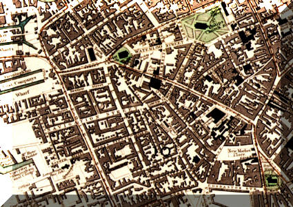
| This map taken from the 1831 Reform act
shows the locations Levi and Sarah Baldwin occupied as indicated by the
parish register entries.
Click the above map for a larger view, this is by necessity a large file and could take up to 2 minutes to load on a 56k modem. The labels relate to dates rather than places e.g.
|
| 1819 | Queen Street |
| 1821 | Wharf Street |
| 1824 | Vale Street |
| 1826 | Dudley Street |
| 1828 | Five Dwellings Off 23 Tonk Street |
| 1829 | Tonk Street |
| 1831 | Tonks Steet (Levi's Widow Sarah) |
| 1836 | Dudley Street (Levi's Son Jeremiah) |
[copyright.htm]